
𝗪𝗵𝘆 𝗱𝗼𝗲𝘀 𝘁𝗵𝗲 𝗨𝗻𝗶𝗳𝗶𝗲𝗱 𝗚𝗲𝗼𝗹𝗼𝗴𝗶𝗰 𝗠𝗮𝗽 𝗠𝗮𝘁𝘁𝗲𝗿 𝗳𝗼𝗿 𝗟𝘂𝗻𝗮𝗿 𝗤𝘂𝗮𝗿𝗿𝘆𝗶𝗻𝗴?
- Roberto Moraes

- Jul 3, 2025
- 2 min read
Updated: Aug 24, 2025
This comprehensive map, built from decades of lunar mission data (Apollo-era, LRO, SELENE), provides a standardized view of the Moon’s geology. For mining and geotechnical engineers, it’s an essential tool for quarry site planning and evaluating material availability.
Key Insights for Quarry Site Planning
𝗜𝗱𝗲𝗻𝘁𝗶𝗳𝘆𝗶𝗻𝗴 𝗢𝗽𝘁𝗶𝗺𝗮𝗹 𝗤𝘂𝗮𝗿𝗿𝘆 𝗦𝗶𝘁𝗲𝘀
🔸The map highlights geological units like impact melt deposits (Ip) and highland materials (Nc), essential for extracting durable aggregates similar to basalt and granite quarries on Earth.
🔸Areas marked with Ec (ejecta) are typically fragmented and unstable, akin to loose alluvial deposits on Earth—making them less favorable for quarrying.
🔸The map also identifies crater interiors, some of which have solidified melt floors (like Ic2) that could serve as quarry basins with stable material.
𝗤𝘂𝗮𝗿𝗿𝘆𝗶𝗻𝗴 𝗳𝗼𝗿 𝗜𝗻𝗳𝗿𝗮𝘀𝘁𝗿𝘂𝗰𝘁𝘂𝗿𝗲 𝗮𝗻𝗱 𝗥𝗼𝗮𝗱 𝗠𝗮𝘁𝗲𝗿𝗶𝗮𝗹𝘀
🔸On Earth, borrow pits provide materials for roads and embankments. On the Moon, basalt-rich impact melts (Ip) and anorthosite highlands (Nc) can serve a similar purpose, offering crushed stone for road bases, embankments, and structural foundations.
🔸The Geologic Map allows us to identify these resource-rich areas, minimizing excavation efforts and ensuring material consistency.
𝗦𝗶𝘁𝗲 𝗦𝘁𝗮𝗯𝗶𝗹𝗶𝘁𝘆 𝗮𝗻𝗱 𝗦𝗮𝗳𝗲𝘁𝘆 𝗔𝘀𝘀𝗲𝘀𝘀𝗺𝗲𝗻𝘁
🔸 The South Pole region shows numerous craters >20 km in diameter, marked with orange circles. Some of these large craters feature stable, flat floors that are ideal for quarrying, while overlapping or concentric craters indicate weaker, disrupted terrain.
🔸 Evaluating crater stability is crucial, much like assessing the risk of sinkholes or subsidence in terrestrial quarries. The map helps pinpoint areas where multi-impact events may have compromised the ground integrity.
𝗢𝗽𝘁𝗶𝗺𝗶𝘇𝗶𝗻𝗴 𝗔𝗰𝗰𝗲𝘀𝘀 𝗮𝗻𝗱 𝗧𝗿𝗮𝗻𝘀𝗽𝗼𝗿𝘁𝗮𝘁𝗶𝗼𝗻
🔸 Just as on Earth, reducing haul distances is vital for efficiency. The map’s data helps us plan material transport corridors between quarry sites and construction zones, minimizing energy consumption.
🔸 Identifying gentle slopes and low-elevation pathways helps in planning lunar roads and infrastructure, similar to selecting haul roads in terrestrial quarries.
Given the vast experience and well-established practices within the extensive mining industry, adapting these proven methods to the Moon is not only feasible but also manageable.
Sources:
🗺️
1.Lunar/LROC - QuickMap // Orange circles represent craters>20km // Unified Geologic Map labels
2.https://https://lnkd.in/gHbHMbzc
3. Quarry Design Handbook by David Jarvis Associates
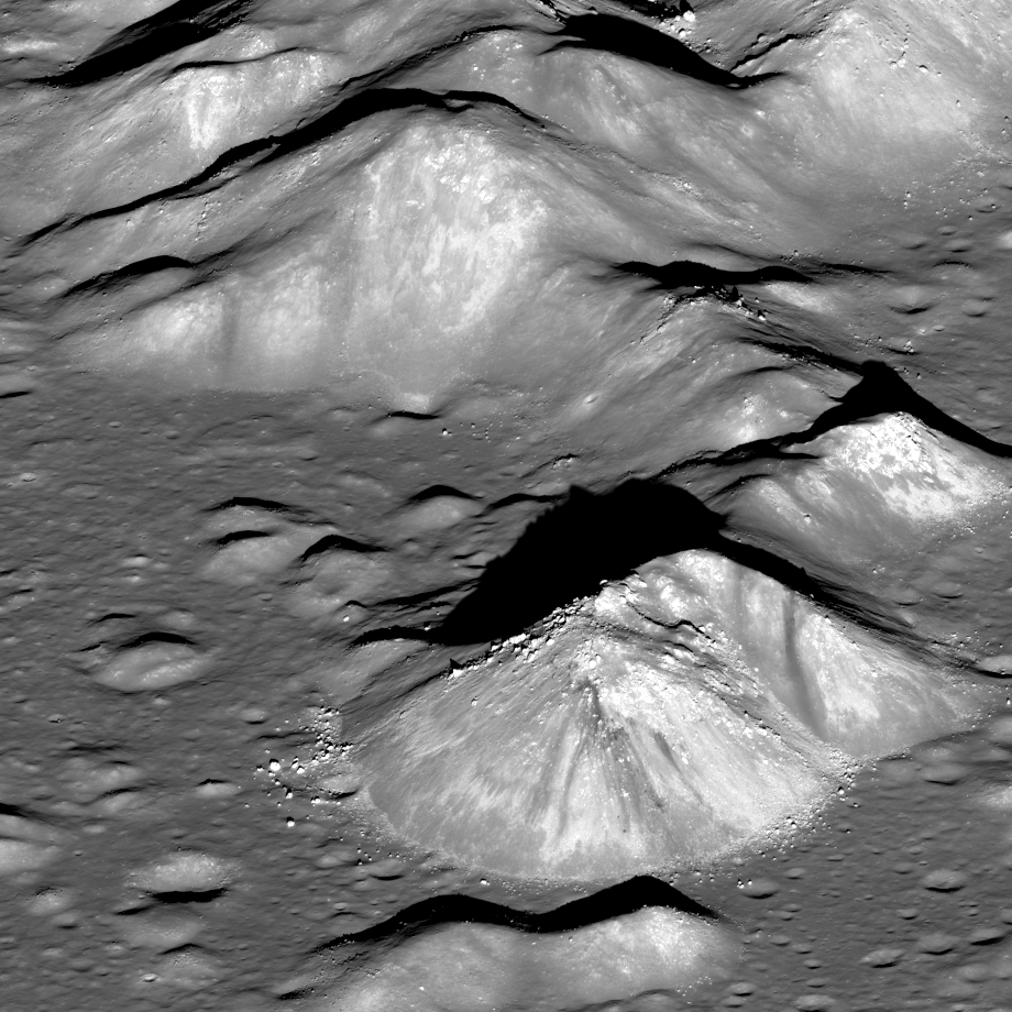
The sharp boundary at the base of the 700-meter-high peak in the foreground
is a frozen sea of impact melt that flooded the crater’s floor in its final
stages of formation. LROC NAC M196665381LR, image is 8 km wide
[NASA/GSFC/Arizona State University].


Comments